
The FOEN Hydrology Division’s basic monitoring network now comprises some 260 gauging stations on surface waters. In addition to lake water levels, river discharge is measured at 200 sites.
Systematic recording of the fundamental parameters of water levels and discharge dates back to the mid-nineteenth century. The long-standing measurement series provide a basis for a wide variety of applications, such as flood protection or investigation of the effects of climate change.
As the data is now rapidly accessible, it can be of great importance to decision makers under extraordinary conditions. In order to guarantee availability of the data, state-of-the-art technology is used for measurement and transmission and flood-proof constructions are maintained.
Explanation of the 'Directory of federal hydrometric gauging stations with digital data, as of 01.01.2023'
The directory covers all federal hydrometric gauging stations on surface waters for which digital data is available on water level, discharge or other parameters (e.g. water temperature, water chemical composition or turbidity). The column 'Operating status' indicates whether a station is currently in operation or discontinued. The column 'Waterbody type' can be used to filter for stations on lakes or rivers.
The data on surface area, mean altitude and glacial area refers in each case to the topographic catchment area. These figures were calculated using the geodataset 'Topographic catchment areas of Swiss waterbodies'. The figures for discontinued stations have been taken from past yearbooks, where available. They are therefore based on different sources.
In some cases, stations have been relocated over time. The station information always refers to the most recent location. In the case of major relocations, the old station has usually been discontinued and a new station put into operation under a new number. Where the difference between the catchment areas of the old and new stations allows, the data of the previous station has been placed in front of the time series of the new station (for discharge gauging stations, only the time series of the discharge). In such cases, both stations are listed in the station directory.
Composite stations (total stations) are a special case. Here, the discharge is measured at two (or more) individual stations: a main station and one or more secondary stations at a different location (e.g. power plant channel, secondary channel of a larger river). These stations are listed individually in the station directories.
The information on data availability refers to the period for which digital data is available at least as a temporal resolution of daily mean values. The federal hydrometric gauging stations for which only paper records are available can be found in the Directory of federal hydrometric gauging stations without digital data.
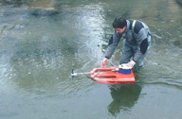
The discharge monitoring stations are calibrated through 5-6 discharge measurements each year. To ensure trouble-free operation, each station is checked by a local observer on a weekly basis.
More information on discharge measuring methods
The hydrology in Switzerland
Beschreibung der Messmethoden ab S. 47
Hydrological measuring stations awarded by the WMO
The FOEN hydrological measuring stations Thur-Andelfingen, Birs-Münchenstein and Sitter-Appenzell have been awarded as Centennial Observing Stations in May 2023.
Hydrological measuring stations awarded by the WMO
Further information
Last modification 26.09.2023

