Zurich lies in the middle of the Sihl flood zone, so damage can be expected in the event of flooding. But where is this damage likely to occur and how severe will it be? And how can it be minimised? We go on a tour of the city with two experts.
Traffic is flowing in front of Zurich central station. Dörte Aller, an experienced risk manager, and Matthias Oplatka, head of the construction section at the cantonal Office of Waste, Water, Energy and Air (AWEL) of the Canton of Zurich, are ready to take us on a tour. Aller starts by telling us, “After this tour, you will see the city in a new light.” She is right.
Flooding underground
We dive into the underground world of Zurich central station. Standing in the midst of the commuter flow, Oplatka explains, “In Zurich, flooding primarily takes place underground. We expect no more than half a metre of water on the surface in most areas, so floods here don’t appear as dramatic as they do in Bern’s Matte district.” Aller adds, “During the last major flood in Zurich, in 1910, people were still driving horse-drawn vehicles through the flooded streets. Today, the consequences would be much worse. What would happen if the station was out of action, even for just one week?” Zurich central station is used by half a million people every day.
So how can this risk be managed? How can it be assessed and evaluated? How can it be reduced? These are questions that Aller and Oplatka have been exploring with other experts and stakeholders since the floods of 2005, when the city almost suffered a catastrophe. That was reason enough to investigate the risks and develop solutions.
We walk through the ShopVille underground shopping centre. Aller recalls the start of the project: “We surveyed the city, which meant exploring it by computer and on foot. We were like detectives. The task was to assess the consequences of a potential flood and to find out which factors most affect the risk. Is it the frequency of floods, the size of the affected area and its use, or the vulnerability of the buildings and installations?” The Sihl not only poses a risk to 3,000 buildings, but also to the city’s infrastructure. “There are countless utility centres, server rooms, and heating and ventilation systems below ground level”, says Oplatka. “If water enters the basements, it becomes dangerous and expensive.”
We return to the surface and walk along Löwenstrasse. “What do you notice?” Aller asks the journalists. “Well – nothing, really.” But there is one small detail: some of the front doors are two steps higher than street level. Oplatka says, “Many of these houses were built soon after 1910, when the memory of the flood was still fresh.” Two steps are enough, he explains, but in the meantime people have forgotten how sensible such simple measures can be.
And how costly can the damage be? “Very costly”, says Oplatka. “For the kind of flood that occurs every couple of hundred years we would have to expect costs of over 6.7 billion Swiss francs.” But it is not possible to put a figure on all damage, such as interruptions to business operations or damage to the environment, which could amount to several times the estimated figure. The choice of protective measures has to take all the risks into account. “This is why it is important to involve all stakeholders early on”, explains Oplatka, “from the various authorities to the affected businesses. That is how we create awareness and understanding, with laypeople and experts exchanging ideas.”
How much risk should we accept?
We stop at the Gessnerallee car park by the river. Next to the exit, three metres below ground level and therefore at risk of flooding, there is a meeting room. “We made a point of holding meetings there”, says Aller. “It creates awareness of the risk. We learnt to change the focus of the discussions.
Instead of just focusing on minimising the risk, we are now considering how much risk we can accept.” If we wanted zero risk, some parts of the city should never have been developed. The aim here, according to Aller, is to find an acceptable balance. “That is an intensive process”, she adds.
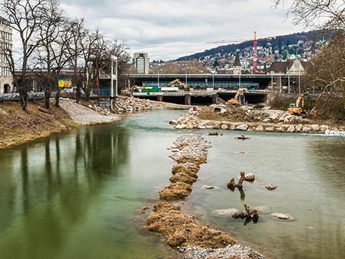
We cross the river via the Gessnerbrücke bridge. Oplatka points to the water. Today, it is flowing calmly under the tracks of Zurich central station. But the Sihl can be wild. As Oplatka says, “Driftwood, cars and construction containers that have been swept away by floodwater can block the space under the bridges. If that happens, this area ends up underwater.” To minimise the frequency with which this situation occurs, the canton has introduced a number of measures to tame the Sihl. However, there is still a residual risk.
Our final stop is Europaallee with its soaring new skyscrapers. Oplatka points to paving slabs arranged around a light well next to one of the buildings. The next time there is a flood – whenever that might be – a mobile guard will be installed here. “Will those responsible still know how it works?” Oplatka asks. A permanent shield is more effective, because no one needs to do anything about it in the heat of the moment. Aller adds, “For all types of measures, one needs to check what impact they have and how reliable they are. Every measure has its use and it is important to know its contribution to risk reduction.”
One of the most important realisations for Oplatka since the floods of 2005 is that to manage risks successfully, everyone involved must be aware of the risk. Flood protection is teamwork, he says, and only works if discussions are ongoing.
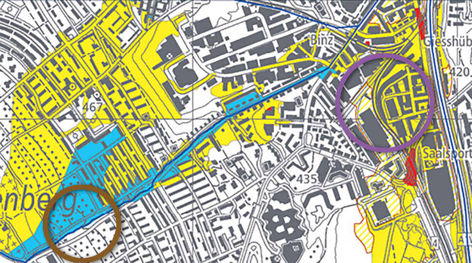
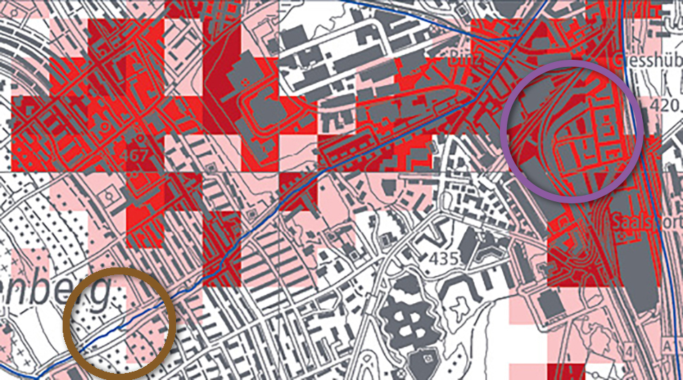
In which areas are people, the environment, property or cultural assets exposed to serious risk? Looking exclusively at the hazard map (left) can lead to wrong conclusions: even in areas where the hazard level is low (yellow), the risk can be high, if it is an area that is used intensively. It is the combination of frequency and intensity of the hazard, the assets affected and the vulnerability to damage that determines the extent of the risk.
For example, in Zurich there is a medium level of hazard along the Kolbenhofbach (brown circle, left) because frequent floods can be expected with a low depth of flooding. The affected assets are few, so the estimated risk is small, or even zero. Along the River Sihl (purple circle, right), the hazard is low because flooding is expected to happen only rarely or very rarely. However, because of the large number of high-value, vulnerable assets in this area (including in the basements), the risk is mediumto high.
Flood hazard levels (combination of frequency and intensity)
The federal government has tasked the cantons with the production of hazard maps, which they must take into account in their planning for urban development and land-use planning. At the same time, the hazard maps are important for raising awareness among the population. Individuals can check the flood hazard level for their area on the relevant page of the FOEN website or on the canton’s geoportal. A guide to reading the hazard maps can be found on the website of the PLANAT, National Platform for Natural Hazards (planat.ch). The new surface runoff risk map went online in summer 2018, showing the flow routes in the event of heavy rainfall (bafu.admin.ch/surface-runoff).
A comprehensive overview of all acute hazards – from forest fires to earthquakes and floods – can be found on the Natural Hazards Portal (naturgefahren.ch) or the MeteoSwiss app. In the event of a natural incident, the authorities issue alerts, warnings and information on the Alertswiss app run by the Federal Office for Civil Protection (FOCP). Experts and emergency response personnel can also access the GIN shared natural hazards information platform (gin.admin.ch).