
The water level and discharge forecasts are based on hydrological and meteorological data and the hydrological model WaSiM. The quality of the hydrological forecasts is affected by various factors such as the size of the catchment and its hydrological complexity, and by the weather conditions.
Hydrological models
The FOEN has been using the FEWS (Flood Early Warning System) forecasting system for several years. FEWS is therefore the principal tool of the forecasters. It offers a program environment which processes management, validation and visualisation of the input data (e.g. measurements, numerical weather models) and the results (hydrological forecasts). The integrated hydrological model WaSiM which computes the actual forecasts is initiated in FEWS.
Quality of the hydrological forecasts
In hydrological terms Switzerland is extremely complex and difficult to model due to its alpine topography, the resultant structuring of the terrain into small units and the substantial anthropogenic influences (regulation of lake levels, hydropower use).
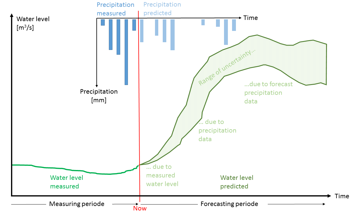
Folgende Punkte beeinflussen die Qualität der Abflussvorhersagen:
- Catchment size: Discharge forecasts for large catchments are more accurate than for smaller ones. In large catchments, errors in numerical weather prediction cancel each other out. Meteorological and hydrological data coverage is also superior in large catchments. Small or medium-sized catchments often have only a few monitoring stations. Smaller areas are altered in some places by human intervention (e.g. power plants).
- Precipitation forecast and snowmelt: In calculating discharge forecasts, the numerical weather prediction model ICON (Icosahedral Nonhydrostatic Weather and Climate Model) from MeteoSwiss and the deterministic flow model from ECMWF (European Centre for Medium-Range Weather Forecasts) are used. Even small deviations from the actual intensity, time and location of precipitation events can give rise to significant errors in relation to the location, peak level and timing of flooding. For predictions of snowmelt, temperature is a crucial factor. Particularly when snow is lying in the Central Plateau, a difference between the forecast and measured temperatures of only one degree can lead to significant errors in the calculation of snowmelt contributions.
- Lake regulation: Apart from Lake Constance and Lake Walen, all of Switzerland's major lakes are regulated. Weir control operations are carried out on the basis of agreed regulation requirements allowed for in the hydrological model. In flood situations, it is not unusual for departures from these requirements to be necessary at short notice. These changes cannot be taken into account in the model.
- Missing data – Computed output data: A number of key hydrological parameters are not determined comprehensively in real time. Thus, for example, snow water equivalent, soil moisture and evaporation must be computed in the model from other variables. This leads to uncertainties in the initial conditions and therefore also in the calculations for the future.
- Regional characteristics: For a hydrological model to be able to represent the hydrological cycle as accurately as possible and - with input from a numerical weather prediction model - to provide precise discharge forecasts, the model needs to be calibrated against observed meteorological and hydrological data. The best results are achieved with calibration for areas not subject to human influences and for which adequate data is available. More problematic are areas with complex regional characteristics (e.g. karst), heavily influenced by hydropower and regulation operations, and with inadequate meteorological data coverage.
- Forecasting period uncertainty: Forecasts for the next few hours are relatively good as they are based on measured data. As the forecast extends further into the future, the quality deteriorates. Forecasts extending beyond 12 hours into the future are not based on measured data; they are based on meteorological predictions, reducing the accuracy of the hydrological forecasts.
Further information
Last modification 27.05.2024

