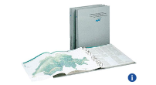
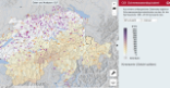
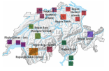
The Hydrological Atlas of Switzerland (HADES) is a platform on the topic of water. It includes maps in printed and digital form, teaching material for use at secondary level and a series of excursion guides aimed at different target groups. HADES celebrates its 30th anniversary in 2018.
The "Hydrological Atlas of Switzerland" is a systematic collection of plates (map sheets) on hydrology in Switzerland. The plates are
divided into the following chapters: fundamental maps, precipitation, snow and glaciers, evaporation, rivers and lakes, soil and groundwater, water balance, and material balances (physical and chemical aspects).
Atlas, teaching material and excursion guide
The atlas provides a data and information platform for science, practice, schools and the public on the topic of water. In addition to the maps, whose base data can also be used digitally through the internet, the atlas also provides teaching material entitled “WASSERverstehen” (“Understanding WATER”) for secondary level students and a series of excursion guides "Wege durch die Wasserwelt" ("Tracks along the Water World ") for various regions in Switzerland. Both the teaching material and the excursion guides will be continuously extended and supplemented with new modules and guides. In August 2017, the new teaching aid “Wallis – Wassernutzung im Wandel” (“Valais – changes in water usage”) was published. Three new guides with excursions in the North East Switzerland region will appear in spring 2018.
The interactive platform

A digital interactive platform featuring hydrological topics has been available since June 2016. The launch took place jointly with the Digital Atlas of Switzerland, which is maintained by the Institute of Cartography and Geoinformation at the Swiss Federal Institute of Technology in Zurich (ETHZ). The platform is continually expanded with new topics and maps. Some of these can be combined and viewed in 3 dimensions. Other functionalities will be added to the platform during 2018: A new two-dimensional data and analysis platform will enable interested parties to filter, download and analyse raster, vector and recording station data.
The Hydrological Atlas of Switzerland is a federal programme which is implemented under the aegis of the FOEN. The project is managed by the Institute of Geography at the University of Bern.
Various events will be taking place to mark the 30th anniversary of the Hydrological Atlas. The authors of selected excursion guides
will be leading walks in several regions through their “Wege durch die Wasserwelt [Tracks along the Water World]” and inviting interested persons to discover the hydrological aspects of their environment. Further information on the events and registration facilities for the excursions will be posted continuously at www.hydrologischeratlas.ch.
More information about the Hydrological Atlas of Switzerland:
Geodataset "Hydrographische Gliederung der Schweiz"
Hydrographische Gliederung der Schweiz (ZIP, 5 MB, 26.07.2017)Data status 2007
Further information
Last modification 06.03.2018